Continuing on the topic of history, there is one place in Busan you can hardly find in tourist brochure. I came to know this place is via a Japanese documentary on the dispute of Dokdo/Takeshima. I'm not going into details about it, but what I'm going to do today, is to introduce this place as a historic site. If you were to take the subway to Suyeong Station via Line 2 or 3, you may see the following mural inside the station.

For those of you who can read hanja, it stated 左水營漁坊, in which in those days, fishermen gathered here to trade their catch, thus the fishing net. The mural depicts an activity related to the fishing song. You can read more about it at Suyeong District Council website, click here for Chinese, and here for English, both has slightly different content. What is more interesting about this mural though, is the facial expression of the depicted fishermen. I'm not sure whether it's graffiti or a deliberate drawing to give a light and humourous touch to the mural. Take a look and judge for yourself.


What is more interesting than the mural, is a park situated near to the subway station, the Suyeong Park (수영공원 水營公園). This is no ordinary park, as it is lined with various cultural assets in just a small area. Suyeong District Council has some writeup on these places, but unfortunately does not promote it well enough to draw people over to visit. The park is probably only popular among local senior citizen to socialise among themselves. Signs leading towards the park are mostly in Korean only, so I'll do some translation for those of you interested to visit this place, and know which item to click when visiting the district council website.


| Korean | Hanja | English |
| 수영사적공원 | 水營史蹟公園 | Suyeong Historic Remains Park |
| 25의용단 | 25義勇壇 | 25 Man Volunteer Army Altar |
| 안용복장군사당 | 安龍福將軍祠堂 | Shrine of General Ahn Yong-Bok |
| 수영민속예술관 | 水營民俗藝術館 | Suyeong Folk Art Centre |
| 수영성남문 | 水營城南門 | Suyeong Fortress South Gate |
| 수영사적원 | 水營史蹟院 | Suyeong History Museum |
| 수영동곰솔 | 水營洞곰솔 | Suyong-dong Black Pine |
| 야외놀이마당 | 野外놀이마당 | Outdoor Open Court |
| 수영동푸조나무 | 水營洞푸조나무 | Suyeong-dong Pujo Tree |
| 공영주차장 | 公營駐車場 | Public Car Park |
Here's the map of Suyeong Park:

The fortress site of Jwasuyeong information board first caught my attention when I reached there. The fortress is Busan Monument No. 8, which the English and Korean information on the board is way more than Japanese or Chinese. If you can't see clearly from the picture, I retyped it as it is (nothing has been changed, including mistakes especially in Chinese and the inconsistent use of traditional/simplified characters) for those of you interested in reading it. After reading it, you might understand more about the significance of this place.

This is the site of the main fortress of the Gyeongsangchwado naval forces during the Joseon period. At one time, seven naval ports with a total of 65 battle ships and 40 auxiliary vessels were under its command and charged with the defense of the east coast area. The command post was first located at Busanpo, then relocated at Gaeunpo in Ulsan, and immediately before the Japanese Invasions of 1592, was moved to this place. It was moved to Gammanipo during the reign of King Injo (1623-49) and moved back here in 1652, the third year of the reign of King Hyojong (1649-59). Thereafeter, it remained at this site, until the naval forces were disbanded in the overall reformation of the military systems in 1895. The time of the original contruction of the wall-fortress here is not known, but the wall-fortress to which th existing remains belong seems to have been built after the relocation of the headquarters to this place in 1652. At that time, the wall-fortress was 2,784 meters in circumference and 4 meters in height. It had three wells, four gates, four drain-outlets and a number of small bulwakrs along the wall. Most of the facilities have been ruined due to the lack of proper care during the Japanese Occupation (1910-45) and there remain only parts of the wall, the arched south gate, and drain-outlets.
此城址是庆尚左道水军的大本营,也是左水营设置的军事防御施设。现在的城?是1652年以後筑成的, 由於管理疏忽,大部分已成废墟。现在只留有南门,虹霓,和排水门。
Here are some of the photos in the park, and have a stroll around the park if you want to see more of this place.


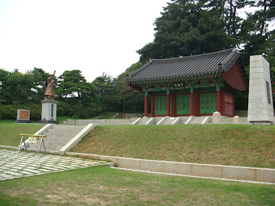
General Ahn Yong-Bok Shrine


Picture above shows the Jwasuyeong Fortress South Gate, also known as 주작문(朱雀門). Apparently, the two dog statues by the side is one of the kind and hardly found elsewhere.

This tree above is Natural Monument No. 311, in which is the Pujo tree stated on the signboard. What is so special about the tree? I will retype the information shown on the display board next to it.
Pseudo Hackberry (Celtis japonica planchon) in Suyeongdong, Busan
This giant tree is more than 500 years old. It is 18m in height, its trunk is 8.5m in circumference, and the branches spread 22.8m east to west and 18.5m north to south. There are several oddly-shaped lumps on the trunk. The villagers revere the tree as their tutelary, believing that it is inhabited by the spirit of a grandmother who protects them from evils. The pseudo-hackberry is a tall deciduos tree widely found int he middle and southern portions of the Korean peninsula. It has alternate ellipse-shaped leaves from 5cm to 10cm long, with saw-typed edges. Seven to twelve pairs of veins run to the final end of edges of the leaves. It blooms in May and its ball-shaped black fruits ripen in October and are covered with short downy hairs.水营洞 朴树
朴树属於榉树科,是落叶乔木,主要分布於中南部地方,这棵朴树树龄在五百年以上,村里的居民都把这棵树看得非常神圣,认为这棵树能保护村子的安宁和繁荣,把它认为是唐山木,或是地神木。

Finally, I'll show you a stone inside the park that describes the 8 beautiful sceneries of Suyeong.

No comments:
Post a Comment