


Okay, I can't believe myself that I've done another round of hiking in such short span from my previous hike. Plus, we took on the highest mountain in Busan, 금정산(金井山), with its highest peak 고당봉(姑堂峰) at 801.5m. Photographs below are courtesy of Yun Yi, our professional photographer.

It was a lovely day, where I made my first mistake of the day to get down at the wrong bus stop. We walked to the entrance to 금강공원(金剛公園) to take the cable car up, which cost ₩3,500 for one way (₩6,000 for return). The five minutes ride view is amazing, but as you get higher during summer, it's foggy as usual, with nothing to see other than the clouds.

One of the main objective for us is to visit all 4 fortress gates (South → East → West → North), which we did. Here's the proof.
금정산성남문(金井山城南門)

금정산성동문(金井山城東門)

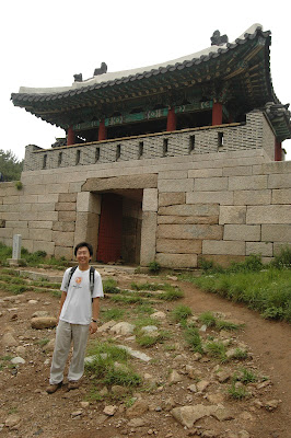
금정산성서문(金井山城西門)

금정산성북문(金井山城北門)
Of all gates, the West gate is the most secluded of all, no signboard showing how to get there and full of overgrown plants. I guess a lot of people will give West gate a skip as it is really out of the way, but its the only gate that has a river (대천천, tribunary of 낙동강) flowing next to it, which was rather nice. Also we discovered something interesting instead. There is actually a village within the fortress, which is famous for its barbeque black goat, and the village has its own 막걸리. Also, check out the village website here to better understand the village.

Getting to the North gate will require a hike on the tar road from the village until a junction to the right, and another 2km of garvel trail with an abandoned church along the way. At that point, the altitude is roughly 665m or so from sea level. From there, approximately 800m up will leads to the 고당봉. The view on top was amazing. Right behind it is the city of 양산, which you can see 낙동강 and its tribunary from 양산. Refer to the first map for location.


After screaming at the peak, we decided to head back home. By the time we get to North gate again, mistake No. 2, choosing 범어사 approach. Night fell earlier than expected and we had to rely on our cell phone to provide glimpse of light to show us the way. It was a rather dangerous experience I think, and shouldn't be done in the first place. I kept hearing water flowing nearby and afraid might step into the wrong path. Lucky that there was rope to mark the territory and I had to make sure I didn't step into the waterfall type of river. Do not try this in Malaysia as the trees are more dense, and thus darker. See Yun Yi's post here and here to read her part of the experience.
One piece of advice, the 범어사 approach is though interesting, but it's a long and challenging 2.5km route, and with a presumably scenic river flowing next to it, but potentially dangerous way to do it in the dark, which was what we did. At any time while hiking, always stay within the defined trail, and do not go beyond it. However scary it might be, if you don't panic, you will get to your destination safely.
If anyone of you would like to give it a try, if you like to see the scenic route, do it early. If you plan to do it easy, I would recommend taking bus either from 동래 or 화명동 towards 산성마을 and start from there. 범어사 approach is best during broad daylight and non-rainy day. After this hike, I guess both of them who came along made it to my expanding list of people that are afraid of going out with me, which also includes Hofun, Yu Shu, Shiew Woei, Chun Wei .....


